
King County’s Project: Ensuring Future Access to 40,000 Historic Maps

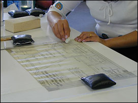
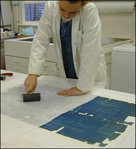
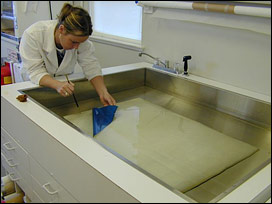
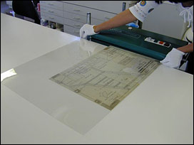
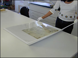
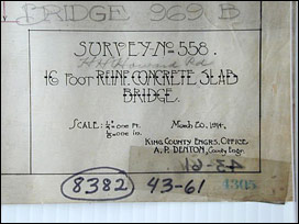

Fraser Spafford Ricci Art & Archival Conservation Inc. has worked for several years with King County Roads Services Division, preserving maps and drawings as part of the county’s digital reproduction project. The project objectives are practical: to achieve a good quality scanned image and to ensure long-term stability of the maps. The collection consists of approximately 40,000 maps that require cleaning, stabilization, treatment and new storage housings. With such a large quantity of material to be preserved, a defined protocol was set up to ensure that cost-efficiency objectives were met. Background Since the late 1990s, King County (a county including the city of Seattle in the state of Washington) Road Services Division has been digitally reproducing (scanning) and preserving over 40,000 maps and drawings that document the development of the county. The Department’s Map and Records Center is responsible for maintaining records and providing information to the public on roads, bridges and older developments. The documents, some from the 1800s and early 1900s, have continuing value in the daily operations of the division as well as significant historic use in tracking the evolution of roads and bridges. The Department is responsible for archiving the maps so that they may be retrieved for legal purposes and in case a digital copy is compromised or becomes inaccessible. It was early in the digitization project that KC Roads staff realized that many of their maps were in disrepair and some too delicate to handle and safely scan. The maps were becoming more difficult to read over time due to presence of dirt, darkening adhesive tape and sometimes darkening supports. The maps were primarily stored tightly rolled in pigeonholes and boxes, and not easily viewed without causing damage. The staff was afraid that, over time, vital information on the maps may be lost. In 1999, Fraser Spafford Ricci Inc. was contracted to stabilize and preserve the maps and prepare them for safe scanning, long-term storage, and future accessibility. Initial Assessment In the beginning of the project, the conservators examined a large sample of maps, recorded their condition and assessed the effect of damage and deterioration on the integrity of the maps. FSR also analyzed the processes of access, handling, scanning (in a feed scanner) and temporary storage utilized by the KC Roads staff. The conservators determined that certain physical conditions would adversely affect the quality of a scanned image ( i.e.. the degree to which information could be accessed from the maps) and these included excessive dirt and grime, staining, discoloration, adhesive tape in the area of writing, planar deformation, structural damage, fragility and a rolled format. Solutions for Safe Scanning and Storage FSR worked with KC Roads to improve safe (archival) handling and workflow procedures and temporary storage techniques during the sorting and scanning process. Conservators also worked closely with King County Archives, the repository of the archived maps. It was determined that maps would first be conserved, then scanned at KC Roads and then sent to the archives for retention. FSR would ensure that the maps would arrive at the archives already processed. There, they would be stored in conditions that meet long-term rigorous archival storage standards within the lowest possible budget. An assessment of the maps early in the project identified damage through retrieval, handling and storage as major risk factors. To minimize these risks, FSR applied a storage solution that they had first piloted at the Yukon Archives in northern Canada. This low-cost system utilizes a primary housing (encapsulation or sleeves) to protect the map during handling, secondary housing (lab-produced folders) for internal transit and to organize the collection, and then flat shelf storage of the folders on a racking system. Metal racks were designed by FSR and constructed for the King County Archives. Methodology and Treatment FSR conservators designed a conservation methodology that laid out how maps would be selected and prioritized, and a rationale for treatment that ensures each map is stabilized. By stabilizing all maps to resolve the most egregious conditions and risk factors, and then treating only some maps according to the priority of “preserving information”, FSR has been able to conserve the maximum number of maps within a defined budget but still meet traditional preservation requirements. Since the rationale is strictly defined and the Roads staff signs off on all detailed treatments, there has been an uncommon level of project accountability. At the Fraser Spafford Ricci lab, maps are sorted and graded into standard categories according to a flowchart of criteria. Most of the maps fall into categories requiring dry surface cleaning and the removal of adhesive tapes that directly affect the image. A selected number receive extensive treatment. Written and digital image documentation of condition and treatment is completed and stored on an Access database.
Leave a Reply
You must be logged in to post a comment.